The Atmospheric Bully: Why the Impending 'Super El Niño' Demands Global Attention
As the Climate Prediction Center prepares to officially designate a 'Super El Niño,' the world braces for a volatile winter defined by extreme weather and shifting economic currents.
As the Climate Prediction Center prepares to officially designate a 'Super El Niño,' the world braces for a volatile winter defined by extreme weather and shifting economic currents.
As the Climate Prediction Center prepares to officially designate a 'Super El Niño,' the world braces for a volatile winter defined by extreme weather and shifting economic currents.
As the Climate Prediction Center prepares to officially designate a 'Super El Niño,' the world braces for a volatile winter defined by extreme weather and shifting economic currents.
As the Climate Prediction Center prepares to officially designate a 'Super El Niño,' the world braces for a volatile winter defined by extreme weather and shifting economic currents.
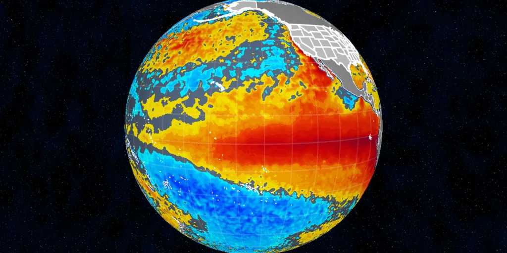
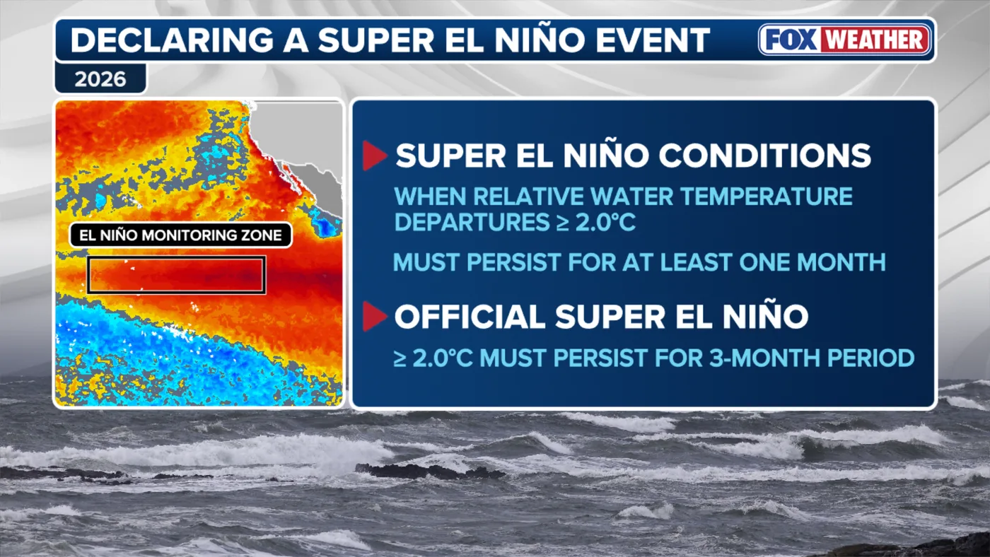
- A 'Super El Niño' is triggered when equatorial Pacific water temperatures exceed 2°C above average for three consecutive months.
- The phenomenon acts as a global atmospheric 'conveyor belt,' shifting jet streams and altering precipitation patterns from the Amazon to the U.S. Southern Tier.
- Historical precedents like the 1997-98 winter suggest a high risk of extreme flooding, ice storms, and unpredictable agricultural disruptions.
- Beyond immediate weather, the event serves as a grim preview of how climate change may amplify natural cycles, threatening global food security and infrastructure.
- A 'Super El Niño' is triggered when equatorial Pacific water temperatures exceed 2°C above average for three consecutive months.
- The phenomenon acts as a global atmospheric 'conveyor belt,' shifting jet streams and altering precipitation patterns from the Amazon to the U.S. Southern Tier.
- Historical precedents like the 1997-98 winter suggest a high risk of extreme flooding, ice storms, and unpredictable agricultural disruptions.
- Beyond immediate weather, the event serves as a grim preview of how climate change may amplify natural cycles, threatening global food security and infrastructure.
- A 'Super El Niño' is triggered when equatorial Pacific water temperatures exceed 2°C above average for three consecutive months.
- The phenomenon acts as a global atmospheric 'conveyor belt,' shifting jet streams and altering precipitation patterns from the Amazon to the U.S. Southern Tier.
- Historical precedents like the 1997-98 winter suggest a high risk of extreme flooding, ice storms, and unpredictable agricultural disruptions.
- Beyond immediate weather, the event serves as a grim preview of how climate change may amplify natural cycles, threatening global food security and infrastructure.
- A 'Super El Niño' is triggered when equatorial Pacific water temperatures exceed 2°C above average for three consecutive months.
- The phenomenon acts as a global atmospheric 'conveyor belt,' shifting jet streams and altering precipitation patterns from the Amazon to the U.S. Southern Tier.
- Historical precedents like the 1997-98 winter suggest a high risk of extreme flooding, ice storms, and unpredictable agricultural disruptions.
- Beyond immediate weather, the event serves as a grim preview of how climate change may amplify natural cycles, threatening global food security and infrastructure.
- A 'Super El Niño' is triggered when equatorial Pacific water temperatures exceed 2°C above average for three consecutive months.
- The phenomenon acts as a global atmospheric 'conveyor belt,' shifting jet streams and altering precipitation patterns from the Amazon to the U.S. Southern Tier.
- Historical precedents like the 1997-98 winter suggest a high risk of extreme flooding, ice storms, and unpredictable agricultural disruptions.
- Beyond immediate weather, the event serves as a grim preview of how climate change may amplify natural cycles, threatening global food security and infrastructure.
In the quiet, high-stakes corridors of the Climate Prediction Center, a definitive shift is underway. Within hours, meteorologists are expected to formally codify what has been brewing in the equatorial Pacific for months: the arrival of a 'Super El Niño.' This is not merely a seasonal fluctuation; it is a profound atmospheric recalibration, a climate phenomenon that acts as a global engine of volatility. By pushing ocean temperatures at least 2 degrees Celsius above the historical average, this event is poised to rewrite the weather narrative for the coming winter, turning the Pacific into a massive heat-exchanger that dictates the fortunes of farmers, insurers, and governments across the Northern and Southern Hemispheres.
The implications of this designation extend far beyond the technical jargon of sea-surface anomalies. As the Pacific jet stream stretches and intensifies, it functions as a meteorological conveyor belt, dragging storms across the Southern United States while simultaneously starving other regions of essential moisture. For the global community, the 'Super' prefix is a warning of systemic disruption. From the drought-stricken reaches of the Amazon to the flood-prone landscapes of California, the world is entering a period where the predictability of the seasons is being systematically dismantled by the sheer kinetic energy of this oceanic giant.
The Anatomy of a Climate Titan
To understand the gravity of a Super El Niño, one must look at the sheer scale of the energy transfer involved. The ocean, possessing a heat-retention capacity roughly 1,000 times greater than the atmosphere, acts as the planet’s primary thermal battery. When a band of warm water forms off the coast of South America—as it has been doing with increasing intensity since late spring—it doesn't just warm the local air; it fundamentally alters the global circulation of the atmosphere. The threshold of 2 degrees Celsius is the critical tipping point that separates a standard El Niño from its 'Super' counterpart, a distinction that has historically signaled catastrophic weather events.
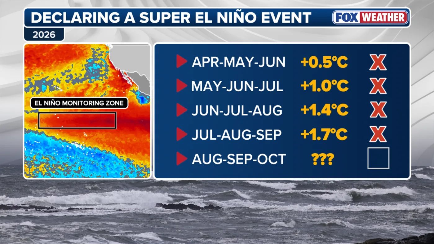
The current event has been a slow-motion collision with reality. While initial assessments for the July-September window fell just shy of the 'Very Strong' classification, the August-October data has confirmed the breach of the 2°C threshold. This confirms a trajectory that meteorologists have been tracking with growing concern. Unlike the record-breaking, under-active Atlantic hurricane season—where wind shear dampened storm development—the Pacific has been a cauldron of activity. This dichotomy is the hallmark of El Niño: it suppresses one region while supercharging another, creating a zero-sum game of atmospheric chaos that leaves no continent untouched.
Historical Echoes and the 1997-98 Precedent
History serves as both a guide and a cautionary tale. Forecasters are currently looking to the 1997-98 winter as the most accurate analog for the months ahead. That period remains etched in the collective memory of climatologists for its sheer unpredictability: a massive October snowstorm that stretched from Colorado to Maine, followed by a New Year’s period defined by historic flooding and ice storms that paralyzed the Midwest and the Northeast. The 2015-16 cycle provided another data point, yet the current event is unfolding against a backdrop of a warming planet that may be fundamentally altering the baseline for these phenomena.
The interaction between this Super El Niño and the polar vortex—the frigid, swirling mass of air at the North Pole—is perhaps the most volatile variable. When these two systems collide, they can scramble weather patterns in ways that defy traditional modeling. For the Midwest, this might mean a reprieve from the harshest cold, but for the Southeast and the Southern Tier, it suggests a winter of relentless precipitation. The uncertainty is not merely academic; it is a challenge to the infrastructure of modern life, from the power grids that must withstand ice storms to the agricultural supply chains that depend on stable, predictable moisture levels.
Global Ripple Effects and Economic Vulnerability
The economic fallout of a Super El Niño is as profound as its meteorological impact. In the Pacific islands, the threat is twofold: a drier wet season that increases wildfire risk, followed by the potential for severe drought that could cripple local agriculture by 2027. In the United States, the focus shifts to the Southern Tier, where the increased storm frequency threatens to disrupt logistics, construction, and property insurance markets. The 'Super' designation is a signal for risk managers to recalibrate their outlooks, as the probability of 'black swan' weather events increases significantly during these periods.
Furthermore, the humanitarian dimension cannot be overlooked. Scientists have estimated that the cumulative heat and weather shifts associated with such strong events can have devastating impacts on global health and food security. As the Amazon faces drought and the Horn of Africa grapples with extreme rainfall, the global supply of commodities—from coffee and cocoa to wheat and corn—faces a period of acute vulnerability. This is the 'atmospheric bully' in action: a natural cycle that, when pushed to its extreme, forces the global economy to pay the price for the planet's shifting thermal equilibrium.
Institutional Readiness and the Path Forward
As the Climate Prediction Center makes its official declaration, the focus of the international community must shift toward resilience. While we cannot stop the movement of the Pacific currents, we can mitigate the impact on the most vulnerable populations. This involves everything from clearing dry vegetation in fire-prone regions like Hawaiʻi to reinforcing flood defenses in the Southern U.S. The institutional response must be as dynamic as the weather itself, moving away from static seasonal forecasts toward real-time, adaptive management strategies.
Looking ahead, the question remains: is this the new normal? While research into the link between anthropogenic climate change and the frequency of Super El Niños is ongoing, the current event provides a chilling preview of a future where the extremes of our climate system are amplified. We are no longer dealing with a simple, cyclical weather pattern; we are witnessing the intersection of natural variability and a warming world. As we navigate the coming winter, the official designation of this Super El Niño should serve as a clarion call for a more robust, integrated approach to global climate monitoring and disaster preparedness. The atmosphere has flexed its muscles; it is now up to us to ensure our systems are strong enough to withstand the blow.
In the quiet, high-stakes corridors of the Climate Prediction Center, a definitive shift is underway. Within hours, meteorologists are expected to formally codify what has been brewing in the equatorial Pacific for months: the arrival of a 'Super El Niño.' This is not merely a seasonal fluctuation; it is a profound atmospheric recalibration, a climate phenomenon that acts as a global engine of volatility. By pushing ocean temperatures at least 2 degrees Celsius above the historical average, this event is poised to rewrite the weather narrative for the coming winter, turning the Pacific into a massive heat-exchanger that dictates the fortunes of farmers, insurers, and governments across the Northern and Southern Hemispheres.
The implications of this designation extend far beyond the technical jargon of sea-surface anomalies. As the Pacific jet stream stretches and intensifies, it functions as a meteorological conveyor belt, dragging storms across the Southern United States while simultaneously starving other regions of essential moisture. For the global community, the 'Super' prefix is a warning of systemic disruption. From the drought-stricken reaches of the Amazon to the flood-prone landscapes of California, the world is entering a period where the predictability of the seasons is being systematically dismantled by the sheer kinetic energy of this oceanic giant.
The Anatomy of a Climate Titan
To understand the gravity of a Super El Niño, one must look at the sheer scale of the energy transfer involved. The ocean, possessing a heat-retention capacity roughly 1,000 times greater than the atmosphere, acts as the planet’s primary thermal battery. When a band of warm water forms off the coast of South America—as it has been doing with increasing intensity since late spring—it doesn't just warm the local air; it fundamentally alters the global circulation of the atmosphere. The threshold of 2 degrees Celsius is the critical tipping point that separates a standard El Niño from its 'Super' counterpart, a distinction that has historically signaled catastrophic weather events.
The current event has been a slow-motion collision with reality. While initial assessments for the July-September window fell just shy of the 'Very Strong' classification, the August-October data has confirmed the breach of the 2°C threshold. This confirms a trajectory that meteorologists have been tracking with growing concern. Unlike the record-breaking, under-active Atlantic hurricane season—where wind shear dampened storm development—the Pacific has been a cauldron of activity. This dichotomy is the hallmark of El Niño: it suppresses one region while supercharging another, creating a zero-sum game of atmospheric chaos that leaves no continent untouched.
Historical Echoes and the 1997-98 Precedent
History serves as both a guide and a cautionary tale. Forecasters are currently looking to the 1997-98 winter as the most accurate analog for the months ahead. That period remains etched in the collective memory of climatologists for its sheer unpredictability: a massive October snowstorm that stretched from Colorado to Maine, followed by a New Year’s period defined by historic flooding and ice storms that paralyzed the Midwest and the Northeast. The 2015-16 cycle provided another data point, yet the current event is unfolding against a backdrop of a warming planet that may be fundamentally altering the baseline for these phenomena.
The interaction between this Super El Niño and the polar vortex—the frigid, swirling mass of air at the North Pole—is perhaps the most volatile variable. When these two systems collide, they can scramble weather patterns in ways that defy traditional modeling. For the Midwest, this might mean a reprieve from the harshest cold, but for the Southeast and the Southern Tier, it suggests a winter of relentless precipitation. The uncertainty is not merely academic; it is a challenge to the infrastructure of modern life, from the power grids that must withstand ice storms to the agricultural supply chains that depend on stable, predictable moisture levels.
Global Ripple Effects and Economic Vulnerability
The economic fallout of a Super El Niño is as profound as its meteorological impact. In the Pacific islands, the threat is twofold: a drier wet season that increases wildfire risk, followed by the potential for severe drought that could cripple local agriculture by 2027. In the United States, the focus shifts to the Southern Tier, where the increased storm frequency threatens to disrupt logistics, construction, and property insurance markets. The 'Super' designation is a signal for risk managers to recalibrate their outlooks, as the probability of 'black swan' weather events increases significantly during these periods.
Furthermore, the humanitarian dimension cannot be overlooked. Scientists have estimated that the cumulative heat and weather shifts associated with such strong events can have devastating impacts on global health and food security. As the Amazon faces drought and the Horn of Africa grapples with extreme rainfall, the global supply of commodities—from coffee and cocoa to wheat and corn—faces a period of acute vulnerability. This is the 'atmospheric bully' in action: a natural cycle that, when pushed to its extreme, forces the global economy to pay the price for the planet's shifting thermal equilibrium.
Institutional Readiness and the Path Forward
As the Climate Prediction Center makes its official declaration, the focus of the international community must shift toward resilience. While we cannot stop the movement of the Pacific currents, we can mitigate the impact on the most vulnerable populations. This involves everything from clearing dry vegetation in fire-prone regions like Hawaiʻi to reinforcing flood defenses in the Southern U.S. The institutional response must be as dynamic as the weather itself, moving away from static seasonal forecasts toward real-time, adaptive management strategies.
Looking ahead, the question remains: is this the new normal? While research into the link between anthropogenic climate change and the frequency of Super El Niños is ongoing, the current event provides a chilling preview of a future where the extremes of our climate system are amplified. We are no longer dealing with a simple, cyclical weather pattern; we are witnessing the intersection of natural variability and a warming world. As we navigate the coming winter, the official designation of this Super El Niño should serve as a clarion call for a more robust, integrated approach to global climate monitoring and disaster preparedness. The atmosphere has flexed its muscles; it is now up to us to ensure our systems are strong enough to withstand the blow.
In the quiet, high-stakes corridors of the Climate Prediction Center, a definitive shift is underway. Within hours, meteorologists are expected to formally codify what has been brewing in the equatorial Pacific for months: the arrival of a 'Super El Niño.' This is not merely a seasonal fluctuation; it is a profound atmospheric recalibration, a climate phenomenon that acts as a global engine of volatility. By pushing ocean temperatures at least 2 degrees Celsius above the historical average, this event is poised to rewrite the weather narrative for the coming winter, turning the Pacific into a massive heat-exchanger that dictates the fortunes of farmers, insurers, and governments across the Northern and Southern Hemispheres.
The implications of this designation extend far beyond the technical jargon of sea-surface anomalies. As the Pacific jet stream stretches and intensifies, it functions as a meteorological conveyor belt, dragging storms across the Southern United States while simultaneously starving other regions of essential moisture. For the global community, the 'Super' prefix is a warning of systemic disruption. From the drought-stricken reaches of the Amazon to the flood-prone landscapes of California, the world is entering a period where the predictability of the seasons is being systematically dismantled by the sheer kinetic energy of this oceanic giant.
The Anatomy of a Climate Titan
To understand the gravity of a Super El Niño, one must look at the sheer scale of the energy transfer involved. The ocean, possessing a heat-retention capacity roughly 1,000 times greater than the atmosphere, acts as the planet’s primary thermal battery. When a band of warm water forms off the coast of South America—as it has been doing with increasing intensity since late spring—it doesn't just warm the local air; it fundamentally alters the global circulation of the atmosphere. The threshold of 2 degrees Celsius is the critical tipping point that separates a standard El Niño from its 'Super' counterpart, a distinction that has historically signaled catastrophic weather events.
The current event has been a slow-motion collision with reality. While initial assessments for the July-September window fell just shy of the 'Very Strong' classification, the August-October data has confirmed the breach of the 2°C threshold. This confirms a trajectory that meteorologists have been tracking with growing concern. Unlike the record-breaking, under-active Atlantic hurricane season—where wind shear dampened storm development—the Pacific has been a cauldron of activity. This dichotomy is the hallmark of El Niño: it suppresses one region while supercharging another, creating a zero-sum game of atmospheric chaos that leaves no continent untouched.
Historical Echoes and the 1997-98 Precedent
History serves as both a guide and a cautionary tale. Forecasters are currently looking to the 1997-98 winter as the most accurate analog for the months ahead. That period remains etched in the collective memory of climatologists for its sheer unpredictability: a massive October snowstorm that stretched from Colorado to Maine, followed by a New Year’s period defined by historic flooding and ice storms that paralyzed the Midwest and the Northeast. The 2015-16 cycle provided another data point, yet the current event is unfolding against a backdrop of a warming planet that may be fundamentally altering the baseline for these phenomena.
The interaction between this Super El Niño and the polar vortex—the frigid, swirling mass of air at the North Pole—is perhaps the most volatile variable. When these two systems collide, they can scramble weather patterns in ways that defy traditional modeling. For the Midwest, this might mean a reprieve from the harshest cold, but for the Southeast and the Southern Tier, it suggests a winter of relentless precipitation. The uncertainty is not merely academic; it is a challenge to the infrastructure of modern life, from the power grids that must withstand ice storms to the agricultural supply chains that depend on stable, predictable moisture levels.
Global Ripple Effects and Economic Vulnerability
The economic fallout of a Super El Niño is as profound as its meteorological impact. In the Pacific islands, the threat is twofold: a drier wet season that increases wildfire risk, followed by the potential for severe drought that could cripple local agriculture by 2027. In the United States, the focus shifts to the Southern Tier, where the increased storm frequency threatens to disrupt logistics, construction, and property insurance markets. The 'Super' designation is a signal for risk managers to recalibrate their outlooks, as the probability of 'black swan' weather events increases significantly during these periods.
Furthermore, the humanitarian dimension cannot be overlooked. Scientists have estimated that the cumulative heat and weather shifts associated with such strong events can have devastating impacts on global health and food security. As the Amazon faces drought and the Horn of Africa grapples with extreme rainfall, the global supply of commodities—from coffee and cocoa to wheat and corn—faces a period of acute vulnerability. This is the 'atmospheric bully' in action: a natural cycle that, when pushed to its extreme, forces the global economy to pay the price for the planet's shifting thermal equilibrium.
Institutional Readiness and the Path Forward
As the Climate Prediction Center makes its official declaration, the focus of the international community must shift toward resilience. While we cannot stop the movement of the Pacific currents, we can mitigate the impact on the most vulnerable populations. This involves everything from clearing dry vegetation in fire-prone regions like Hawaiʻi to reinforcing flood defenses in the Southern U.S. The institutional response must be as dynamic as the weather itself, moving away from static seasonal forecasts toward real-time, adaptive management strategies.
Looking ahead, the question remains: is this the new normal? While research into the link between anthropogenic climate change and the frequency of Super El Niños is ongoing, the current event provides a chilling preview of a future where the extremes of our climate system are amplified. We are no longer dealing with a simple, cyclical weather pattern; we are witnessing the intersection of natural variability and a warming world. As we navigate the coming winter, the official designation of this Super El Niño should serve as a clarion call for a more robust, integrated approach to global climate monitoring and disaster preparedness. The atmosphere has flexed its muscles; it is now up to us to ensure our systems are strong enough to withstand the blow.
In the quiet, high-stakes corridors of the Climate Prediction Center, a definitive shift is underway. Within hours, meteorologists are expected to formally codify what has been brewing in the equatorial Pacific for months: the arrival of a 'Super El Niño.' This is not merely a seasonal fluctuation; it is a profound atmospheric recalibration, a climate phenomenon that acts as a global engine of volatility. By pushing ocean temperatures at least 2 degrees Celsius above the historical average, this event is poised to rewrite the weather narrative for the coming winter, turning the Pacific into a massive heat-exchanger that dictates the fortunes of farmers, insurers, and governments across the Northern and Southern Hemispheres.
The implications of this designation extend far beyond the technical jargon of sea-surface anomalies. As the Pacific jet stream stretches and intensifies, it functions as a meteorological conveyor belt, dragging storms across the Southern United States while simultaneously starving other regions of essential moisture. For the global community, the 'Super' prefix is a warning of systemic disruption. From the drought-stricken reaches of the Amazon to the flood-prone landscapes of California, the world is entering a period where the predictability of the seasons is being systematically dismantled by the sheer kinetic energy of this oceanic giant.
The Anatomy of a Climate Titan
To understand the gravity of a Super El Niño, one must look at the sheer scale of the energy transfer involved. The ocean, possessing a heat-retention capacity roughly 1,000 times greater than the atmosphere, acts as the planet’s primary thermal battery. When a band of warm water forms off the coast of South America—as it has been doing with increasing intensity since late spring—it doesn't just warm the local air; it fundamentally alters the global circulation of the atmosphere. The threshold of 2 degrees Celsius is the critical tipping point that separates a standard El Niño from its 'Super' counterpart, a distinction that has historically signaled catastrophic weather events.
The current event has been a slow-motion collision with reality. While initial assessments for the July-September window fell just shy of the 'Very Strong' classification, the August-October data has confirmed the breach of the 2°C threshold. This confirms a trajectory that meteorologists have been tracking with growing concern. Unlike the record-breaking, under-active Atlantic hurricane season—where wind shear dampened storm development—the Pacific has been a cauldron of activity. This dichotomy is the hallmark of El Niño: it suppresses one region while supercharging another, creating a zero-sum game of atmospheric chaos that leaves no continent untouched.
Historical Echoes and the 1997-98 Precedent
History serves as both a guide and a cautionary tale. Forecasters are currently looking to the 1997-98 winter as the most accurate analog for the months ahead. That period remains etched in the collective memory of climatologists for its sheer unpredictability: a massive October snowstorm that stretched from Colorado to Maine, followed by a New Year’s period defined by historic flooding and ice storms that paralyzed the Midwest and the Northeast. The 2015-16 cycle provided another data point, yet the current event is unfolding against a backdrop of a warming planet that may be fundamentally altering the baseline for these phenomena.
The interaction between this Super El Niño and the polar vortex—the frigid, swirling mass of air at the North Pole—is perhaps the most volatile variable. When these two systems collide, they can scramble weather patterns in ways that defy traditional modeling. For the Midwest, this might mean a reprieve from the harshest cold, but for the Southeast and the Southern Tier, it suggests a winter of relentless precipitation. The uncertainty is not merely academic; it is a challenge to the infrastructure of modern life, from the power grids that must withstand ice storms to the agricultural supply chains that depend on stable, predictable moisture levels.
Global Ripple Effects and Economic Vulnerability
The economic fallout of a Super El Niño is as profound as its meteorological impact. In the Pacific islands, the threat is twofold: a drier wet season that increases wildfire risk, followed by the potential for severe drought that could cripple local agriculture by 2027. In the United States, the focus shifts to the Southern Tier, where the increased storm frequency threatens to disrupt logistics, construction, and property insurance markets. The 'Super' designation is a signal for risk managers to recalibrate their outlooks, as the probability of 'black swan' weather events increases significantly during these periods.
Furthermore, the humanitarian dimension cannot be overlooked. Scientists have estimated that the cumulative heat and weather shifts associated with such strong events can have devastating impacts on global health and food security. As the Amazon faces drought and the Horn of Africa grapples with extreme rainfall, the global supply of commodities—from coffee and cocoa to wheat and corn—faces a period of acute vulnerability. This is the 'atmospheric bully' in action: a natural cycle that, when pushed to its extreme, forces the global economy to pay the price for the planet's shifting thermal equilibrium.
Institutional Readiness and the Path Forward
As the Climate Prediction Center makes its official declaration, the focus of the international community must shift toward resilience. While we cannot stop the movement of the Pacific currents, we can mitigate the impact on the most vulnerable populations. This involves everything from clearing dry vegetation in fire-prone regions like Hawaiʻi to reinforcing flood defenses in the Southern U.S. The institutional response must be as dynamic as the weather itself, moving away from static seasonal forecasts toward real-time, adaptive management strategies.
Looking ahead, the question remains: is this the new normal? While research into the link between anthropogenic climate change and the frequency of Super El Niños is ongoing, the current event provides a chilling preview of a future where the extremes of our climate system are amplified. We are no longer dealing with a simple, cyclical weather pattern; we are witnessing the intersection of natural variability and a warming world. As we navigate the coming winter, the official designation of this Super El Niño should serve as a clarion call for a more robust, integrated approach to global climate monitoring and disaster preparedness. The atmosphere has flexed its muscles; it is now up to us to ensure our systems are strong enough to withstand the blow.
In the quiet, high-stakes corridors of the Climate Prediction Center, a definitive shift is underway. Within hours, meteorologists are expected to formally codify what has been brewing in the equatorial Pacific for months: the arrival of a 'Super El Niño.' This is not merely a seasonal fluctuation; it is a profound atmospheric recalibration, a climate phenomenon that acts as a global engine of volatility. By pushing ocean temperatures at least 2 degrees Celsius above the historical average, this event is poised to rewrite the weather narrative for the coming winter, turning the Pacific into a massive heat-exchanger that dictates the fortunes of farmers, insurers, and governments across the Northern and Southern Hemispheres.
The implications of this designation extend far beyond the technical jargon of sea-surface anomalies. As the Pacific jet stream stretches and intensifies, it functions as a meteorological conveyor belt, dragging storms across the Southern United States while simultaneously starving other regions of essential moisture. For the global community, the 'Super' prefix is a warning of systemic disruption. From the drought-stricken reaches of the Amazon to the flood-prone landscapes of California, the world is entering a period where the predictability of the seasons is being systematically dismantled by the sheer kinetic energy of this oceanic giant.
The Anatomy of a Climate Titan
To understand the gravity of a Super El Niño, one must look at the sheer scale of the energy transfer involved. The ocean, possessing a heat-retention capacity roughly 1,000 times greater than the atmosphere, acts as the planet’s primary thermal battery. When a band of warm water forms off the coast of South America—as it has been doing with increasing intensity since late spring—it doesn't just warm the local air; it fundamentally alters the global circulation of the atmosphere. The threshold of 2 degrees Celsius is the critical tipping point that separates a standard El Niño from its 'Super' counterpart, a distinction that has historically signaled catastrophic weather events.
The current event has been a slow-motion collision with reality. While initial assessments for the July-September window fell just shy of the 'Very Strong' classification, the August-October data has confirmed the breach of the 2°C threshold. This confirms a trajectory that meteorologists have been tracking with growing concern. Unlike the record-breaking, under-active Atlantic hurricane season—where wind shear dampened storm development—the Pacific has been a cauldron of activity. This dichotomy is the hallmark of El Niño: it suppresses one region while supercharging another, creating a zero-sum game of atmospheric chaos that leaves no continent untouched.
Historical Echoes and the 1997-98 Precedent
History serves as both a guide and a cautionary tale. Forecasters are currently looking to the 1997-98 winter as the most accurate analog for the months ahead. That period remains etched in the collective memory of climatologists for its sheer unpredictability: a massive October snowstorm that stretched from Colorado to Maine, followed by a New Year’s period defined by historic flooding and ice storms that paralyzed the Midwest and the Northeast. The 2015-16 cycle provided another data point, yet the current event is unfolding against a backdrop of a warming planet that may be fundamentally altering the baseline for these phenomena.
The interaction between this Super El Niño and the polar vortex—the frigid, swirling mass of air at the North Pole—is perhaps the most volatile variable. When these two systems collide, they can scramble weather patterns in ways that defy traditional modeling. For the Midwest, this might mean a reprieve from the harshest cold, but for the Southeast and the Southern Tier, it suggests a winter of relentless precipitation. The uncertainty is not merely academic; it is a challenge to the infrastructure of modern life, from the power grids that must withstand ice storms to the agricultural supply chains that depend on stable, predictable moisture levels.
Global Ripple Effects and Economic Vulnerability
The economic fallout of a Super El Niño is as profound as its meteorological impact. In the Pacific islands, the threat is twofold: a drier wet season that increases wildfire risk, followed by the potential for severe drought that could cripple local agriculture by 2027. In the United States, the focus shifts to the Southern Tier, where the increased storm frequency threatens to disrupt logistics, construction, and property insurance markets. The 'Super' designation is a signal for risk managers to recalibrate their outlooks, as the probability of 'black swan' weather events increases significantly during these periods.
Furthermore, the humanitarian dimension cannot be overlooked. Scientists have estimated that the cumulative heat and weather shifts associated with such strong events can have devastating impacts on global health and food security. As the Amazon faces drought and the Horn of Africa grapples with extreme rainfall, the global supply of commodities—from coffee and cocoa to wheat and corn—faces a period of acute vulnerability. This is the 'atmospheric bully' in action: a natural cycle that, when pushed to its extreme, forces the global economy to pay the price for the planet's shifting thermal equilibrium.
Institutional Readiness and the Path Forward
As the Climate Prediction Center makes its official declaration, the focus of the international community must shift toward resilience. While we cannot stop the movement of the Pacific currents, we can mitigate the impact on the most vulnerable populations. This involves everything from clearing dry vegetation in fire-prone regions like Hawaiʻi to reinforcing flood defenses in the Southern U.S. The institutional response must be as dynamic as the weather itself, moving away from static seasonal forecasts toward real-time, adaptive management strategies.
Looking ahead, the question remains: is this the new normal? While research into the link between anthropogenic climate change and the frequency of Super El Niños is ongoing, the current event provides a chilling preview of a future where the extremes of our climate system are amplified. We are no longer dealing with a simple, cyclical weather pattern; we are witnessing the intersection of natural variability and a warming world. As we navigate the coming winter, the official designation of this Super El Niño should serve as a clarion call for a more robust, integrated approach to global climate monitoring and disaster preparedness. The atmosphere has flexed its muscles; it is now up to us to ensure our systems are strong enough to withstand the blow.
Editorial Standards & Multi-Language Synthesis: This dispatch was synthesized and fact-checked by the ParisDaily Editorial Desk across 5 global editions (EN, FR, VI, ES, ZH), cross-referencing primary international wire reports and real-time search intelligence.